


toue du marais de montfort

CABERMAT
User
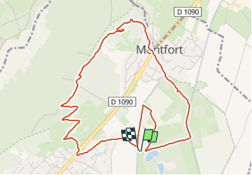

Length
6 km

Max alt
368 m

Uphill gradient
147 m
Km-Effort
8 km

Min alt
225 m

Downhill gradient
147 m
Boucle
Yes
Creation date :
2024-01-04 12:48:54.257
Updated on :
2024-01-15 16:17:21.314
1h57
Difficulty : Medium

FREE GPS app for hiking
 SityTrail
IGN / Geographical institutes
SityTrail Plus
The world is yours!
About
Trail Walking of 6 km to be discovered at Auvergne-Rhône-Alpes, Isère, Crolles. This trail is proposed by CABERMAT.
Positioning
Country:
France
Region :
Auvergne-Rhône-Alpes
Department/Province :
Isère
Municipality :
Crolles
Location:
Unknown
Start:(Dec)
Start:(UTM)
727203 ; 5019198 (31T) N.
Comments