


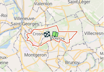
Yerres -Crosne- Bois de la Grange- Yerres 12 km

jeanmarcMasson
User GUIDE

Length
12.3 km

Max alt
116 m

Uphill gradient
124 m
Km-Effort
14 km

Min alt
31 m

Downhill gradient
123 m
Boucle
Yes
Creation date :
2024-01-16 18:07:55.478
Updated on :
2024-01-16 18:10:39.107
3h10
Difficulty : Difficult

FREE GPS app for hiking
 SityTrail
IGN / Geographical institutes
SityTrail Plus
The world is yours!
About
Trail Walking of 12.3 km to be discovered at Ile-de-France, Essonne, Yerres. This trail is proposed by jeanmarcMasson.
Positioning
Country:
France
Region :
Ile-de-France
Department/Province :
Essonne
Municipality :
Yerres
Location:
Unknown
Start:(Dec)
Start:(UTM)
461714 ; 5395922 (31U) N.
Comments