St Thomé Bayne Viviers 14km

thonyc
User GUIDE
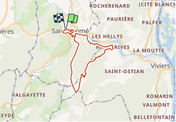

Length
14.1 km

Max alt
371 m

Uphill gradient
456 m
Km-Effort
20 km

Min alt
92 m

Downhill gradient
457 m
Boucle
Yes
Creation date :
2024-01-18 11:06:40.4
Updated on :
2024-01-19 08:59:21.822
4h34
Difficulty : Medium

FREE GPS app for hiking
 SityTrail
IGN / Geographical institutes
SityTrail Plus
The world is yours!
About
Trail Walking of 14.1 km to be discovered at Auvergne-Rhône-Alpes, Ardèche, Saint-Thomé. This trail is proposed by thonyc.
Positioning
Country:
France
Region :
Auvergne-Rhône-Alpes
Department/Province :
Ardèche
Municipality :
Saint-Thomé
Location:
Unknown
Start:(Dec)
Start:(UTM)
629061 ; 4928838 (31T) N.
Comments