


lambersart rl

jeanluc59
User
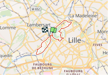

Length
11.4 km

Max alt
30 m

Uphill gradient
94 m
Km-Effort
12.7 km

Min alt
9 m

Downhill gradient
94 m
Boucle
Yes
Creation date :
2024-01-19 15:32:41.247
Updated on :
2024-01-24 11:06:20.13
2h52
Difficulty : Difficult

FREE GPS app for hiking
 SityTrail
IGN / Geographical institutes
SityTrail Plus
The world is yours!
About
Trail Walking of 11.4 km to be discovered at Hauts-de-France, Nord, Lambersart. This trail is proposed by jeanluc59.
Positioning
Country:
France
Region :
Hauts-de-France
Department/Province :
Nord
Municipality :
Lambersart
Location:
Unknown
Start:(Dec)
Start:(UTM)
502434 ; 5609698 (31U) N.
Comments