


tour sinne et observatoire

pastis613
User

Length
128 km

Max alt
709 m

Uphill gradient
2193 m
Km-Effort
155 km

Min alt
23 m

Downhill gradient
1691 m
Boucle
No
Creation date :
2024-01-01 12:47:09.261
Updated on :
2024-01-19 16:17:56.495
55h30
Difficulty : Very difficult

FREE GPS app for hiking
 SityTrail
IGN / Geographical institutes
SityTrail Plus
The world is yours!
About
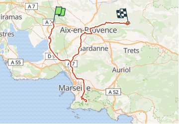
Trail Walking of 128 km to be discovered at Provence-Alpes-Côte d'Azur, Bouches-du-Rhône, Coudoux. This trail is proposed by pastis613.
Positioning
Country:
France
Region :
Provence-Alpes-Côte d'Azur
Department/Province :
Bouches-du-Rhône
Municipality :
Coudoux
Location:
Unknown
Start:(Dec)
Start:(UTM)
682087 ; 4825103 (31T) N.
Comments