


Thynes DEPS

thomarche
User
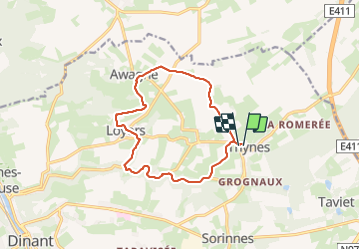

Length
11.7 km

Max alt
292 m

Uphill gradient
215 m
Km-Effort
14.5 km

Min alt
154 m

Downhill gradient
213 m
Boucle
Yes
Creation date :
2024-01-21 13:25:49.0
Updated on :
2024-01-21 16:08:56.397
2h42
Difficulty : Unknown

FREE GPS app for hiking
 SityTrail
IGN / Geographical institutes
SityTrail Plus
The world is yours!
About
Trail Walking of 11.7 km to be discovered at Wallonia, Namur, Dinant. This trail is proposed by thomarche.
Description
Superbe vallée encaissée du Ruisseau du Fond de la Leffe. Puis très beaux chemins. Faite sous grand manteau de neige…
Positioning
Country:
Belgium
Region :
Wallonia
Department/Province :
Namur
Municipality :
Dinant
Location:
Unknown
Start:(Dec)
Start:(UTM)
641534 ; 5571656 (31U) N.
Comments