


Bièvres et le bois de Verrières

Guy Laurent
User
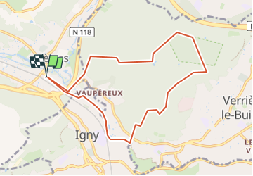

Length
8.4 km

Max alt
182 m

Uphill gradient
139 m
Km-Effort
10.3 km

Min alt
65 m

Downhill gradient
140 m
Boucle
Yes
Creation date :
2024-01-21 16:36:04.44
Updated on :
2024-01-21 16:37:15.111
2h20
Difficulty : Medium

FREE GPS app for hiking
 SityTrail
IGN / Geographical institutes
SityTrail Plus
The world is yours!
About
Trail Walking of 8.4 km to be discovered at Ile-de-France, Essonne, Bièvres. This trail is proposed by Guy Laurent.
Description
Courte boucle
Positioning
Country:
France
Region :
Ile-de-France
Department/Province :
Essonne
Municipality :
Bièvres
Location:
Unknown
Start:(Dec)
Start:(UTM)
442354 ; 5400137 (31U) N.
Comments