


la londe

thle
User
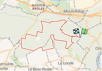

Length
19.5 km

Max alt
156 m

Uphill gradient
362 m
Km-Effort
24 km

Min alt
47 m

Downhill gradient
364 m
Boucle
Yes
Creation date :
2015-03-05 00:00:00.0
Updated on :
2015-03-05 00:00:00.0
3h02
Difficulty : Medium

FREE GPS app for hiking
 SityTrail
IGN / Geographical institutes
SityTrail Plus
The world is yours!
About
Trail Equestrian of 19.5 km to be discovered at Normandy, Seine-Maritime, Orival. This trail is proposed by thle.
Positioning
Country:
France
Region :
Normandy
Department/Province :
Seine-Maritime
Municipality :
Orival
Location:
Unknown
Start:(Dec)
Start:(UTM)
352700 ; 5465068 (31U) N.
Comments