


Balade au départ de La Cheneaudière

BenPep
User
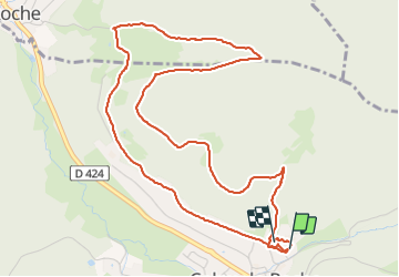

Length
5.8 km

Max alt
643 m

Uphill gradient
233 m
Km-Effort
8.9 km

Min alt
478 m

Downhill gradient
222 m
Boucle
Yes
Creation date :
2024-01-23 09:26:00.054
Updated on :
2024-01-23 11:13:23.468
1h46
Difficulty : Medium

FREE GPS app for hiking
 SityTrail
IGN / Geographical institutes
SityTrail Plus
The world is yours!
About
Trail Walking of 5.8 km to be discovered at Grand Est, Bas-Rhin, Colroy-la-Roche. This trail is proposed by BenPep.
Positioning
Country:
France
Region :
Grand Est
Department/Province :
Bas-Rhin
Municipality :
Colroy-la-Roche
Location:
Unknown
Start:(Dec)
Start:(UTM)
365553 ; 5361366 (32U) N.
Comments