


combloux

janussity
User
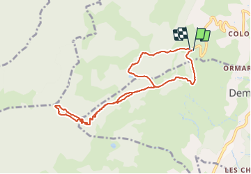

Length
9.3 km

Max alt
1759 m

Uphill gradient
530 m
Km-Effort
16.3 km

Min alt
1267 m

Downhill gradient
530 m
Boucle
Yes
Creation date :
2024-01-22 09:41:16.002
Updated on :
2024-01-23 14:17:44.32
3h10
Difficulty : Difficult

FREE GPS app for hiking
 SityTrail
IGN / Geographical institutes
SityTrail Plus
The world is yours!
About
Trail Walking of 9.3 km to be discovered at Auvergne-Rhône-Alpes, Upper Savoy, Combloux. This trail is proposed by janussity.
Description
pluie àl,'arrivée
Positioning
Country:
France
Region :
Auvergne-Rhône-Alpes
Department/Province :
Upper Savoy
Municipality :
Combloux
Location:
Unknown
Start:(Dec)
Start:(UTM)
315537 ; 5084403 (32T) N.
Comments