


Le plan lachat Valloire

fb30
User
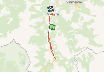

Length
17.6 km

Max alt
1969 m

Uphill gradient
471 m
Km-Effort
24 km

Min alt
1406 m

Downhill gradient
604 m
Boucle
No
Creation date :
2024-01-24 10:07:56.0
Updated on :
2024-01-24 15:16:50.505

FREE GPS app for hiking
 SityTrail
IGN / Geographical institutes
SityTrail Plus
The world is yours!
About
Trail of 17.6 km to be discovered at Auvergne-Rhône-Alpes, Savoy, Valloire. This trail is proposed by fb30.
Description
Très belle montée dans la neige
Positioning
Country:
France
Region :
Auvergne-Rhône-Alpes
Department/Province :
Savoy
Municipality :
Valloire
Location:
Unknown
Start:(Dec)
Start:(UTM)
296997 ; 5000878 (32T) N.
Comments