


tracedetrail_237813

Atchoum26
User
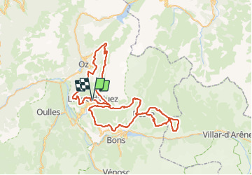

Length
90 km

Max alt
2453 m

Uphill gradient
4691 m
Km-Effort
153 km

Min alt
1086 m

Downhill gradient
4693 m
Boucle
Yes
Creation date :
2024-01-24 18:12:43.0
Updated on :
2024-06-18 09:25:14.478
0m
Difficulty : Very easy

FREE GPS app for hiking
 SityTrail
IGN / Geographical institutes
SityTrail Plus
The world is yours!
About
Trail Trail of 90 km to be discovered at Auvergne-Rhône-Alpes, Isère, Huez. This trail is proposed by Atchoum26.
Description
Oisans Trail Tour
Positioning
Country:
France
Region :
Auvergne-Rhône-Alpes
Department/Province :
Isère
Municipality :
Huez
Location:
Unknown
Start:(Dec)
Start:(UTM)
269437 ; 4997158 (32T) N.
Comments