


saint cyr sur mer

denel
User
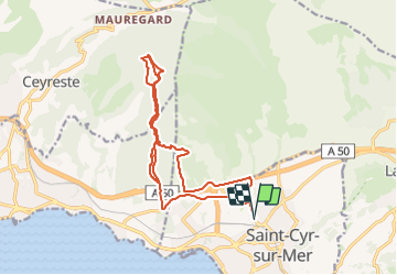

Length
23 km

Max alt
423 m

Uphill gradient
791 m
Km-Effort
34 km

Min alt
33 m

Downhill gradient
790 m
Boucle
Yes
Creation date :
2024-01-27 13:52:10.91
Updated on :
2024-01-27 16:42:39.61
2h50
Difficulty : Difficult

FREE GPS app for hiking
 SityTrail
IGN / Geographical institutes
SityTrail Plus
The world is yours!
About
Trail Mountain bike of 23 km to be discovered at Provence-Alpes-Côte d'Azur, Var, Saint-Cyr-sur-Mer. This trail is proposed by denel.
Positioning
Country:
France
Region :
Provence-Alpes-Côte d'Azur
Department/Province :
Var
Municipality :
Saint-Cyr-sur-Mer
Location:
Unknown
Start:(Dec)
Start:(UTM)
719624 ; 4785134 (31T) N.
Comments