


boulaie achiffet st sauveur angomont

Titinechris
User
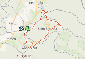

Length
15.1 km

Max alt
519 m

Uphill gradient
411 m
Km-Effort
21 km

Min alt
308 m

Downhill gradient
402 m
Boucle
Yes
Creation date :
2024-01-28 08:44:08.104
Updated on :
2024-01-28 08:44:38.602
0m
Difficulty : Easy

FREE GPS app for hiking
 SityTrail
IGN / Geographical institutes
SityTrail Plus
The world is yours!
About
Trail Trail of 15.1 km to be discovered at Grand Est, Meurthe-et-Moselle, Bréménil. This trail is proposed by Titinechris.
Positioning
Country:
France
Region :
Grand Est
Department/Province :
Meurthe-et-Moselle
Municipality :
Bréménil
Location:
Unknown
Start:(Dec)
Start:(UTM)
347874 ; 5377143 (32U) N.
Comments