


Floreffe DEPS

thomarche
User
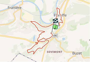

Length
9.5 km

Max alt
193 m

Uphill gradient
180 m
Km-Effort
12.1 km

Min alt
82 m

Downhill gradient
243 m
Boucle
No
Creation date :
2024-01-28 12:11:21.0
Updated on :
2024-01-28 14:21:11.786
2h08
Difficulty : Unknown

FREE GPS app for hiking
 SityTrail
IGN / Geographical institutes
SityTrail Plus
The world is yours!
About
Trail Walking of 9.5 km to be discovered at Wallonia, Namur, Floreffe. This trail is proposed by thomarche.
Positioning
Country:
Belgium
Region :
Wallonia
Department/Province :
Namur
Municipality :
Floreffe
Location:
Floreffe
Start:(Dec)
Start:(UTM)
624606 ; 5587816 (31U) N.
Comments