


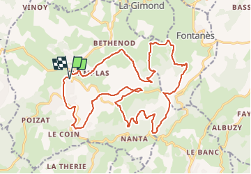
2024-VTT-24.35km-D635 V1

bena42
User

Length
24 km

Max alt
863 m

Uphill gradient
784 m
Km-Effort
35 km

Min alt
644 m

Downhill gradient
783 m
Boucle
Yes
Creation date :
2024-01-29 20:14:00.888
Updated on :
2024-03-15 19:38:22.981
2h24
Difficulty : Difficult

FREE GPS app for hiking
 SityTrail
IGN / Geographical institutes
SityTrail Plus
The world is yours!
About
Trail Mountain bike of 24 km to be discovered at Auvergne-Rhône-Alpes, Loire, Saint-Héand. This trail is proposed by bena42.
Positioning
Country:
France
Region :
Auvergne-Rhône-Alpes
Department/Province :
Loire
Municipality :
Saint-Héand
Location:
Unknown
Start:(Dec)
Start:(UTM)
607409 ; 5042964 (31T) N.
Comments