


20240201-Vandrimare

doudet
User
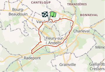

Length
12.2 km

Max alt
132 m

Uphill gradient
203 m
Km-Effort
14.9 km

Min alt
22 m

Downhill gradient
202 m
Boucle
Yes
Creation date :
2024-02-01 12:23:44.131
Updated on :
2024-02-02 06:21:31.067
2h54
Difficulty : Medium

FREE GPS app for hiking
 SityTrail
IGN / Geographical institutes
SityTrail Plus
The world is yours!
About
Trail Walking of 12.2 km to be discovered at Normandy, Eure, Vandrimare. This trail is proposed by doudet.
Description
oucle A-R au départ de la rue des Ecoles
Photos


23 photos in total. Please click on a photo to see them all in the gallery.
Positioning
Country:
France
Region :
Normandy
Department/Province :
Eure
Municipality :
Vandrimare
Location:
Unknown
Start:(Dec)
Start:(UTM)
379925 ; 5470990 (31U) N.
Comments