


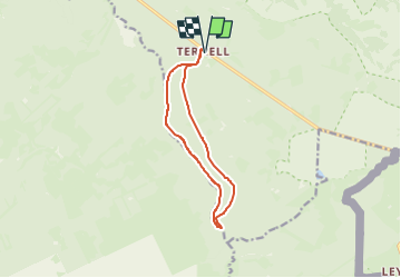
Trail Planner Map

Efr
User

Length
9.8 km

Max alt
581 m

Uphill gradient
174 m
Km-Effort
12.1 km

Min alt
437 m

Downhill gradient
174 m
Boucle
Yes
Creation date :
2024-02-01 20:41:12.946
Updated on :
2024-02-01 21:02:20.833
2h45
Difficulty : Difficult

FREE GPS app for hiking
 SityTrail
IGN / Geographical institutes
SityTrail Plus
The world is yours!
About
Trail Walking of 9.8 km to be discovered at Wallonia, Liège, Eupen. This trail is proposed by Efr.
Description
Depart: Ternell 4700 Eupen (Brasserie Ternell)
Positioning
Country:
Belgium
Region :
Wallonia
Department/Province :
Liège
Municipality :
Eupen
Location:
Eupen (Altgemeinde)
Start:(Dec)
Start:(UTM)
296898 ; 5607673 (32U) N.
Comments