


ST RAPHAEL/ vessyeres/ font du pommier/Mistral/ vallon ubac

Michel DUBOIS
User
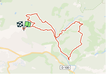

Length
11.9 km

Max alt
119 m

Uphill gradient
274 m
Km-Effort
15.6 km

Min alt
10 m

Downhill gradient
273 m
Boucle
Yes
Creation date :
2024-02-02 15:57:55.407
Updated on :
2024-02-02 15:59:27.677
3h32
Difficulty : Easy

FREE GPS app for hiking
 SityTrail
IGN / Geographical institutes
SityTrail Plus
The world is yours!
About
Trail Walking of 11.9 km to be discovered at Provence-Alpes-Côte d'Azur, Var, Saint-Raphaël. This trail is proposed by Michel DUBOIS.
Positioning
Country:
France
Region :
Provence-Alpes-Côte d'Azur
Department/Province :
Var
Municipality :
Saint-Raphaël
Location:
Unknown
Start:(Dec)
Start:(UTM)
323696 ; 4814274 (32T) N.
Comments