


20240203

fredodlageo
User
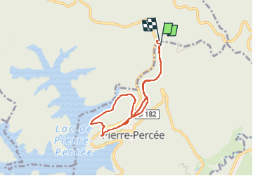

Length
6.7 km

Max alt
492 m

Uphill gradient
206 m
Km-Effort
9.4 km

Min alt
387 m

Downhill gradient
198 m
Boucle
Yes
Creation date :
2024-02-03 15:10:29.0
Updated on :
2024-02-03 17:03:38.795
1h52
Difficulty : Medium

FREE GPS app for hiking
 SityTrail
IGN / Geographical institutes
SityTrail Plus
The world is yours!
About
Trail Walking of 6.7 km to be discovered at Grand Est, Meurthe-et-Moselle, Pierre-Percée. This trail is proposed by fredodlageo.
Description
Rando château izzie
Positioning
Country:
France
Region :
Grand Est
Department/Province :
Meurthe-et-Moselle
Municipality :
Pierre-Percée
Location:
Unknown
Start:(Dec)
Start:(UTM)
347721 ; 5372038 (32U) N.
Comments