


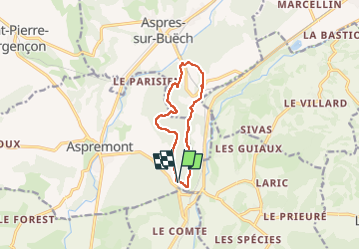
Boucle Col des Ourines Col du Pignon

rigol05
User

Length
9.3 km

Max alt
897 m

Uphill gradient
329 m
Km-Effort
13.7 km

Min alt
762 m

Downhill gradient
324 m
Boucle
Yes
Creation date :
2024-02-04 09:57:44.797
Updated on :
2024-02-05 11:09:31.097
3h06
Difficulty : Medium

FREE GPS app for hiking
 SityTrail
IGN / Geographical institutes
SityTrail Plus
The world is yours!
About
Trail Walking of 9.3 km to be discovered at Provence-Alpes-Côte d'Azur, Hautes-Alpes, Aspremont. This trail is proposed by rigol05.
Description
Variante de la sortie du 02/02/2024 au départ du Col des Ourines
Positioning
Country:
France
Region :
Provence-Alpes-Côte d'Azur
Department/Province :
Hautes-Alpes
Municipality :
Aspremont
Location:
Unknown
Start:(Dec)
Start:(UTM)
719095 ; 4929390 (31T) N.
Comments