


reprise Toto 3/2/24

Tollard
User

Length
30 km

Max alt
267 m

Uphill gradient
543 m
Km-Effort
37 km

Min alt
149 m

Downhill gradient
543 m
Boucle
Yes
Creation date :
2024-02-04 07:57:52.529
Updated on :
2024-02-04 10:45:04.213
2h46
Difficulty : Difficult

FREE GPS app for hiking
 SityTrail
IGN / Geographical institutes
SityTrail Plus
The world is yours!
About
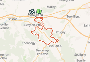
Trail Mountain bike of 30 km to be discovered at Grand Est, Aube, Fontvannes. This trail is proposed by Tollard.
Positioning
Country:
France
Region :
Grand Est
Department/Province :
Aube
Municipality :
Fontvannes
Location:
Unknown
Start:(Dec)
Start:(UTM)
564729 ; 5347043 (31U) N.
Comments