


balade pont

raab
User
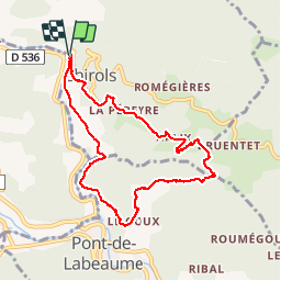

Length
8.8 km

Max alt
532 m

Uphill gradient
247 m
Km-Effort
12.1 km

Min alt
328 m

Downhill gradient
245 m
Boucle
Yes
Creation date :
2018-07-30 16:23:39.165
Updated on :
2018-07-30 16:23:39.173
2h42
Difficulty : Medium

FREE GPS app for hiking
 SityTrail
IGN / Geographical institutes
SityTrail Plus
The world is yours!
About
Trail Walking of 8.8 km to be discovered at Auvergne-Rhône-Alpes, Ardèche, Chirols. This trail is proposed by raab.
Positioning
Country:
France
Region :
Auvergne-Rhône-Alpes
Department/Province :
Ardèche
Municipality :
Chirols
Location:
Unknown
Start:(Dec)
Start:(UTM)
601775 ; 4948993 (31T) N.
Comments