


LA LEQUE - FONS SUR LUSSAN

GOIOLIRIBES
User
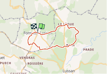

Length
13.4 km

Max alt
330 m

Uphill gradient
203 m
Km-Effort
16.2 km

Min alt
245 m

Downhill gradient
203 m
Boucle
Yes
Creation date :
2024-02-01 08:36:51.681
Updated on :
2024-02-09 07:50:18.731
4h44
Difficulty : Easy

FREE GPS app for hiking
 SityTrail
IGN / Geographical institutes
SityTrail Plus
The world is yours!
About
Trail Walking of 13.4 km to be discovered at Occitania, Gard, Fons-sur-Lussan. This trail is proposed by GOIOLIRIBES.
Description
jolie rando avec de très beaux chemins. rando à faire en hiver, en été trop exposée au soleil.
Photos


Positioning
Country:
France
Region :
Occitania
Department/Province :
Gard
Municipality :
Fons-sur-Lussan
Location:
Unknown
Start:(Dec)
Start:(UTM)
606258 ; 4893261 (31T) N.
Comments