


Jaubernie

raygautier
User
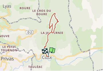

Length
6.5 km

Max alt
452 m

Uphill gradient
274 m
Km-Effort
10.2 km

Min alt
196 m

Downhill gradient
279 m
Boucle
Yes
Creation date :
2024-02-06 13:27:46.0
Updated on :
2024-02-06 15:03:36.104

FREE GPS app for hiking
 SityTrail
IGN / Geographical institutes
SityTrail Plus
The world is yours!
About
Trail of 6.5 km to be discovered at Auvergne-Rhône-Alpes, Ardèche, Coux. This trail is proposed by raygautier.
Positioning
Country:
France
Region :
Auvergne-Rhône-Alpes
Department/Province :
Ardèche
Municipality :
Coux
Location:
Unknown
Start:(Dec)
Start:(UTM)
628527 ; 4954915 (31T) N.
Comments