


Ste Flaive des Loups1

Gascon
User
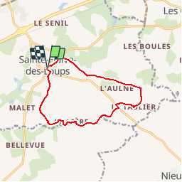

Length
11.5 km

Max alt
76 m

Uphill gradient
81 m
Km-Effort
12.6 km

Min alt
44 m

Downhill gradient
82 m
Boucle
Yes
Creation date :
2016-04-19 00:00:00.0
Updated on :
2016-04-19 00:00:00.0
2h47
Difficulty : Easy

FREE GPS app for hiking
 SityTrail
IGN / Geographical institutes
SityTrail Plus
The world is yours!
About
Trail Walking of 11.5 km to be discovered at Pays de la Loire, Vendée, Sainte-Flaive-des-Loups. This trail is proposed by Gascon.
Positioning
Country:
France
Region :
Pays de la Loire
Department/Province :
Vendée
Municipality :
Sainte-Flaive-des-Loups
Location:
Unknown
Start:(Dec)
Start:(UTM)
608864 ; 5162954 (30T) N.
Comments