


Saint julien en saint alban

raygautier
User
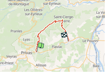

Length
21 km

Max alt
814 m

Uphill gradient
739 m
Km-Effort
31 km

Min alt
132 m

Downhill gradient
813 m
Boucle
No
Creation date :
2024-02-08 08:30:38.0
Updated on :
2024-02-09 09:13:29.135
7h07
Difficulty : Very difficult

FREE GPS app for hiking
 SityTrail
IGN / Geographical institutes
SityTrail Plus
The world is yours!
About
Trail Walking of 21 km to be discovered at Auvergne-Rhône-Alpes, Ardèche, Coux. This trail is proposed by raygautier.
Description
tres belle rando sur les cretes de la montagne serre de cruas
Positioning
Country:
France
Region :
Auvergne-Rhône-Alpes
Department/Province :
Ardèche
Municipality :
Coux
Location:
Unknown
Start:(Dec)
Start:(UTM)
628513 ; 4954924 (31T) N.
Comments