


Vérargues - tour balisé

DiagMan
User
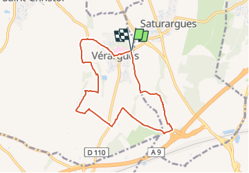

Length
7.8 km

Max alt
60 m

Uphill gradient
77 m
Km-Effort
8.8 km

Min alt
22 m

Downhill gradient
75 m
Boucle
Yes
Creation date :
2024-02-09 18:26:44.52
Updated on :
2024-02-09 18:28:08.436
1h59
Difficulty : Medium

FREE GPS app for hiking
 SityTrail
IGN / Geographical institutes
SityTrail Plus
The world is yours!
About
Trail Walking of 7.8 km to be discovered at Occitania, Hérault, Entre-Vignes. This trail is proposed by DiagMan.
Positioning
Country:
France
Region :
Occitania
Department/Province :
Hérault
Municipality :
Entre-Vignes
Location:
Vérargues
Start:(Dec)
Start:(UTM)
588947 ; 4841081 (31T) N.
Comments