


20240210-St Pierre des Fleurs

doudet
User

Length
12.2 km

Max alt
166 m

Uphill gradient
189 m
Km-Effort
14.7 km

Min alt
96 m

Downhill gradient
189 m
Boucle
Yes
Creation date :
2024-02-10 12:25:07.185
Updated on :
2024-02-12 07:36:30.587
2h59
Difficulty : Medium

FREE GPS app for hiking
 SityTrail
IGN / Geographical institutes
SityTrail Plus
The world is yours!
About
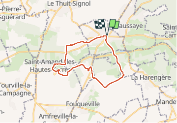
Trail Walking of 12.2 km to be discovered at Normandy, Eure, Saint-Pierre-des-Fleurs. This trail is proposed by doudet.
Description
Boucle A-R au départ de l'eglise
Photos


26 photos in total. Please click on a photo to see them all in the gallery.
Positioning
Country:
France
Region :
Normandy
Department/Province :
Eure
Municipality :
Saint-Pierre-des-Fleurs
Location:
Unknown
Start:(Dec)
Start:(UTM)
352001 ; 5457339 (31U) N.
Comments