


Andenne ADEPS

flocon00007
User
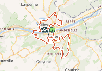

Length
21 km

Max alt
225 m

Uphill gradient
406 m
Km-Effort
27 km

Min alt
67 m

Downhill gradient
406 m
Boucle
Yes
Creation date :
2024-02-10 09:54:06.0
Updated on :
2024-02-10 15:56:28.887
4h52
Difficulty : Easy

FREE GPS app for hiking
 SityTrail
IGN / Geographical institutes
SityTrail Plus
The world is yours!
About
Trail Walking of 21 km to be discovered at Wallonia, Namur, Andenne. This trail is proposed by flocon00007.
Positioning
Country:
Belgium
Region :
Wallonia
Department/Province :
Namur
Municipality :
Andenne
Location:
Unknown
Start:(Dec)
Start:(UTM)
648106 ; 5595147 (31U) N.
Comments