


PONTAIX / col de vachere ,rando kiki

okfred26
User
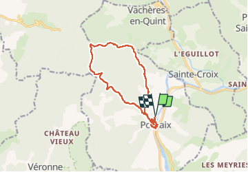

Length
13.7 km

Max alt
885 m

Uphill gradient
597 m
Km-Effort
22 km

Min alt
328 m

Downhill gradient
595 m
Boucle
Yes
Creation date :
2024-02-11 08:47:34.997
Updated on :
2024-02-11 14:56:59.564
6h08
Difficulty : Easy

FREE GPS app for hiking
 SityTrail
IGN / Geographical institutes
SityTrail Plus
The world is yours!
About
Trail Walking of 13.7 km to be discovered at Auvergne-Rhône-Alpes, Drôme, Pontaix. This trail is proposed by okfred26.
Positioning
Country:
France
Region :
Auvergne-Rhône-Alpes
Department/Province :
Drôme
Municipality :
Pontaix
Location:
Unknown
Start:(Dec)
Start:(UTM)
679209 ; 4958099 (31T) N.
Comments