


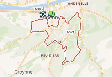
Andenne DEPS

thomarche
User

Length
9.6 km

Max alt
226 m

Uphill gradient
244 m
Km-Effort
12.8 km

Min alt
75 m

Downhill gradient
243 m
Boucle
Yes
Creation date :
2024-02-11 14:02:37.0
Updated on :
2024-02-11 16:26:44.364
2h23
Difficulty : Unknown

FREE GPS app for hiking
 SityTrail
IGN / Geographical institutes
SityTrail Plus
The world is yours!
About
Trail Walking of 9.6 km to be discovered at Wallonia, Namur, Andenne. This trail is proposed by thomarche.
Description
Belles vues et sentiers au-dessus.
Positioning
Country:
Belgium
Region :
Wallonia
Department/Province :
Namur
Municipality :
Andenne
Location:
Unknown
Start:(Dec)
Start:(UTM)
648616 ; 5595008 (31U) N.
Comments