


T-JG-a517-Dourdan-et-sa-forêt

Jack-94
User
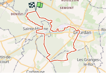

Length
19.8 km

Max alt
172 m

Uphill gradient
330 m
Km-Effort
24 km

Min alt
94 m

Downhill gradient
331 m
Boucle
Yes
Creation date :
2024-02-11 08:21:23.026
Updated on :
2024-02-11 17:36:58.245
6h28
Difficulty : Very difficult

FREE GPS app for hiking
 SityTrail
IGN / Geographical institutes
SityTrail Plus
The world is yours!
About
Trail Walking of 19.8 km to be discovered at Ile-de-France, Essonne, Dourdan. This trail is proposed by Jack-94.
Positioning
Country:
France
Region :
Ile-de-France
Department/Province :
Essonne
Municipality :
Dourdan
Location:
Unknown
Start:(Dec)
Start:(UTM)
423324 ; 5377418 (31U) N.
Comments