


ballade au dessus de Martignat

cailloux54
User

Length
10.8 km

Max alt
760 m

Uphill gradient
273 m
Km-Effort
14.5 km

Min alt
506 m

Downhill gradient
284 m
Boucle
Yes
Creation date :
2024-02-12 07:19:46.151
Updated on :
2024-02-12 09:49:54.176
2h25
Difficulty : Medium

FREE GPS app for hiking
 SityTrail
IGN / Geographical institutes
SityTrail Plus
The world is yours!
About
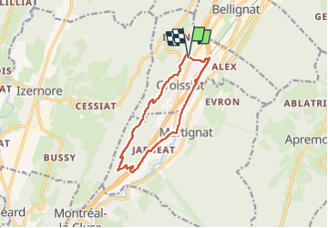
Trail Walking of 10.8 km to be discovered at Auvergne-Rhône-Alpes, Ain, Groissiat. This trail is proposed by cailloux54.
Positioning
Country:
France
Region :
Auvergne-Rhône-Alpes
Department/Province :
Ain
Municipality :
Groissiat
Location:
Unknown
Start:(Dec)
Start:(UTM)
701379 ; 5122852 (31T) N.
Comments