


Saint Aubin

mjh
User
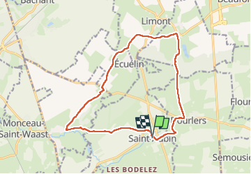

Length
14.3 km

Max alt
201 m

Uphill gradient
158 m
Km-Effort
16.4 km

Min alt
142 m

Downhill gradient
157 m
Boucle
Yes
Creation date :
2024-02-12 11:54:39.94
Updated on :
2024-02-12 16:17:24.271
2h54
Difficulty : Medium

FREE GPS app for hiking
 SityTrail
IGN / Geographical institutes
SityTrail Plus
The world is yours!
About
Trail Walking of 14.3 km to be discovered at Hauts-de-France, Nord, Saint-Aubin. This trail is proposed by mjh.
Photos

Positioning
Country:
France
Region :
Hauts-de-France
Department/Province :
Nord
Municipality :
Saint-Aubin
Location:
Unknown
Start:(Dec)
Start:(UTM)
565750 ; 5557978 (31U) N.
Comments