


13 fevrier

arnoultjf
User
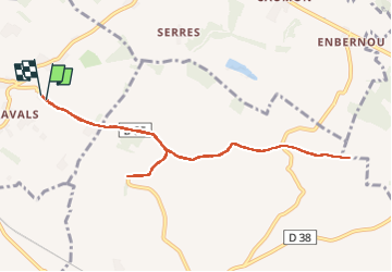

Length
10 km

Max alt
249 m

Uphill gradient
111 m
Km-Effort
11.4 km

Min alt
172 m

Downhill gradient
114 m
Boucle
Yes
Creation date :
2024-02-13 12:49:20.662
Updated on :
2024-02-13 15:09:04.177
2h19
Difficulty : Medium

FREE GPS app for hiking
 SityTrail
IGN / Geographical institutes
SityTrail Plus
The world is yours!
About
Trail Walking of 10 km to be discovered at Occitania, Haute-Garonne, Montlaur. This trail is proposed by arnoultjf.
Positioning
Country:
France
Region :
Occitania
Department/Province :
Haute-Garonne
Municipality :
Montlaur
Location:
Unknown
Start:(Dec)
Start:(UTM)
386356 ; 4815450 (31T) N.
Comments