


hhh

GR192
User
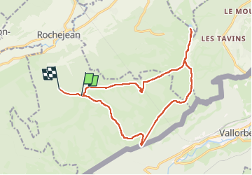

Length
16.8 km

Max alt
1454 m

Uphill gradient
551 m
Km-Effort
24 km

Min alt
1128 m

Downhill gradient
565 m
Boucle
No
Creation date :
2024-02-13 09:50:56.52
Updated on :
2024-02-13 16:19:56.421
4h04
Difficulty : Difficult

FREE GPS app for hiking
 SityTrail
IGN / Geographical institutes
SityTrail Plus
The world is yours!
About
Trail Walking of 16.8 km to be discovered at Bourgogne-Franche-Comté, Doubs, Rochejean. This trail is proposed by GR192.
Positioning
Country:
France
Region :
Bourgogne-Franche-Comté
Department/Province :
Doubs
Municipality :
Rochejean
Location:
Unknown
Start:(Dec)
Start:(UTM)
293911 ; 5178080 (32T) N.
Comments