


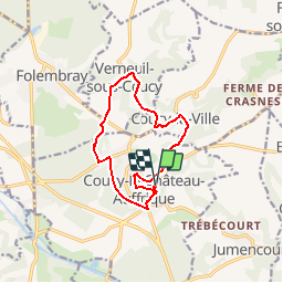
Le circuit d'Enguerrand_trace GPS simplifiée_10,7 km

Pousscailleux
User

Length
10.7 km

Max alt
126 m

Uphill gradient
154 m
Km-Effort
12.8 km

Min alt
51 m

Downhill gradient
155 m
Boucle
Yes
Creation date :
2015-04-13 00:00:00.0
Updated on :
2015-04-13 00:00:00.0
2h49
Difficulty : Difficult

FREE GPS app for hiking
 SityTrail
IGN / Geographical institutes
SityTrail Plus
The world is yours!
About
Trail Walking of 10.7 km to be discovered at Hauts-de-France, Aisne, Coucy-le-Château-Auffrique. This trail is proposed by Pousscailleux.
Description
Départ de la place de l'Hôtel de Ville, N49°31'13,15" /E003°19'28,3".
Itinéraire tiré de la fiche "Le Circuit d'Enguerrand", elle-même extraite du site www.randonner.fr.
Positioning
Country:
France
Region :
Hauts-de-France
Department/Province :
Aisne
Municipality :
Coucy-le-Château-Auffrique
Location:
Unknown
Start:(Dec)
Start:(UTM)
523485 ; 5485352 (31U) N.
Comments