


Puisserguier St Christophe variante

gerardhenr
User
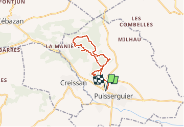

Length
12.6 km

Max alt
194 m

Uphill gradient
284 m
Km-Effort
16.4 km

Min alt
81 m

Downhill gradient
283 m
Boucle
Yes
Creation date :
2015-03-12 00:00:00.0
Updated on :
2015-03-12 00:00:00.0
3h29
Difficulty : Medium

FREE GPS app for hiking
 SityTrail
IGN / Geographical institutes
SityTrail Plus
The world is yours!
About
Trail Walking of 12.6 km to be discovered at Occitania, Hérault, Puisserguier. This trail is proposed by gerardhenr.
Description
Variante car balisage et description du circuit fantaisiste!
Circuit décrit dans "Ballades en Terres d'Orb"page 67

Positioning
Country:
France
Region :
Occitania
Department/Province :
Hérault
Municipality :
Puisserguier
Location:
Unknown
Start:(Dec)
Start:(UTM)
502887 ; 4801956 (31T) N.
Comments