


Quincy - Ru des Hauldres -15 km

jeanmarcMasson
User GUIDE
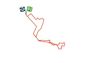

Length
15.6 km

Max alt
102 m

Uphill gradient
89 m
Km-Effort
16.8 km

Min alt
78 m

Downhill gradient
88 m
Boucle
Yes
Creation date :
2024-02-16 09:29:22.001
Updated on :
2024-02-16 09:44:16.389
3h48
Difficulty : Difficult

FREE GPS app for hiking
 SityTrail
IGN / Geographical institutes
SityTrail Plus
The world is yours!
About
Trail Walking of 15.6 km to be discovered at Ile-de-France, Essonne, Quincy-sous-Sénart. This trail is proposed by jeanmarcMasson.
Positioning
Country:
France
Region :
Ile-de-France
Department/Province :
Essonne
Municipality :
Quincy-sous-Sénart
Location:
Unknown
Start:(Dec)
Start:(UTM)
464987 ; 5390206 (31U) N.
Comments