


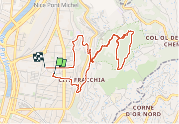
St Roch- Vinaigrier en boucle

PEBREJOSIANE
User

Length
5.9 km

Max alt
352 m

Uphill gradient
335 m
Km-Effort
10.3 km

Min alt
22 m

Downhill gradient
329 m
Boucle
Yes
Creation date :
2024-02-17 08:41:40.25
Updated on :
2024-02-17 10:43:38.563
1h35
Difficulty : Easy

FREE GPS app for hiking
 SityTrail
IGN / Geographical institutes
SityTrail Plus
The world is yours!
About
Trail Walking of 5.9 km to be discovered at Provence-Alpes-Côte d'Azur, Maritime Alps, Nice. This trail is proposed by PEBREJOSIANE.
Description
Départ et arrivée de la place St Roch
Cheminement dans les oliviers
Positioning
Country:
France
Region :
Provence-Alpes-Côte d'Azur
Department/Province :
Maritime Alps
Municipality :
Nice
Location:
Unknown
Start:(Dec)
Start:(UTM)
362333 ; 4841387 (32T) N.
Comments