


entre bertrichamps et rouge vêtu

Titinechris
User
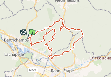

Length
19.9 km

Max alt
423 m

Uphill gradient
401 m
Km-Effort
25 km

Min alt
281 m

Downhill gradient
401 m
Boucle
Yes
Creation date :
2024-02-17 19:00:33.114
Updated on :
2024-02-17 19:02:40.138
0m
Difficulty : Easy

FREE GPS app for hiking
 SityTrail
IGN / Geographical institutes
SityTrail Plus
The world is yours!
About
Trail Trail of 19.9 km to be discovered at Grand Est, Meurthe-et-Moselle, Bertrichamps. This trail is proposed by Titinechris.
Positioning
Country:
France
Region :
Grand Est
Department/Province :
Meurthe-et-Moselle
Municipality :
Bertrichamps
Location:
Unknown
Start:(Dec)
Start:(UTM)
337656 ; 5366469 (32U) N.
Comments