


Tour d'Aigrefoin (Gif)

Guy Laurent
User
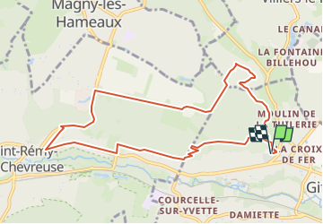

Length
9.9 km

Max alt
165 m

Uphill gradient
222 m
Km-Effort
12.8 km

Min alt
76 m

Downhill gradient
222 m
Boucle
Yes
Creation date :
2024-02-19 13:30:46.315
Updated on :
2024-02-19 13:31:38.901
2h54
Difficulty : Difficult

FREE GPS app for hiking
 SityTrail
IGN / Geographical institutes
SityTrail Plus
The world is yours!
About
Trail Walking of 9.9 km to be discovered at Ile-de-France, Essonne, Gif-sur-Yvette. This trail is proposed by Guy Laurent.
Positioning
Country:
France
Region :
Ile-de-France
Department/Province :
Essonne
Municipality :
Gif-sur-Yvette
Location:
Unknown
Start:(Dec)
Start:(UTM)
435183 ; 5395158 (31U) N.
Comments