


Apremont_La remise Neuve_Trace GPS simplifiée_10,1km

Pousscailleux
User
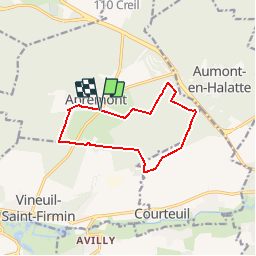

Length
10.1 km

Max alt
95 m

Uphill gradient
94 m
Km-Effort
11.4 km

Min alt
51 m

Downhill gradient
93 m
Boucle
Yes
Creation date :
2015-03-16 00:00:00.0
Updated on :
2015-03-16 00:00:00.0
2h31
Difficulty : Easy

FREE GPS app for hiking
 SityTrail
IGN / Geographical institutes
SityTrail Plus
The world is yours!
About
Trail Walking of 10.1 km to be discovered at Hauts-de-France, Oise, Apremont. This trail is proposed by Pousscailleux.
Description
Départ du parking du Polo d'Apremont.
Positioning
Country:
France
Region :
Hauts-de-France
Department/Province :
Oise
Municipality :
Apremont
Location:
Unknown
Start:(Dec)
Start:(UTM)
464548 ; 5452254 (31U) N.
Comments