


tour haut kemberg

Titinechris
User
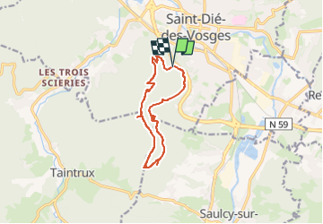

Length
11.1 km

Max alt
739 m

Uphill gradient
515 m
Km-Effort
18 km

Min alt
411 m

Downhill gradient
520 m
Boucle
Yes
Creation date :
2024-02-23 11:31:21.334
Updated on :
2024-02-23 11:31:57.77
4h05
Difficulty : Difficult

FREE GPS app for hiking
 SityTrail
IGN / Geographical institutes
SityTrail Plus
The world is yours!
About
Trail Walking of 11.1 km to be discovered at Grand Est, Vosges, Saint-Dié-des-Vosges. This trail is proposed by Titinechris.
Positioning
Country:
France
Region :
Grand Est
Department/Province :
Vosges
Municipality :
Saint-Dié-des-Vosges
Location:
Unknown
Start:(Dec)
Start:(UTM)
347086 ; 5349135 (32U) N.
Comments