


a517

Jack-94
User
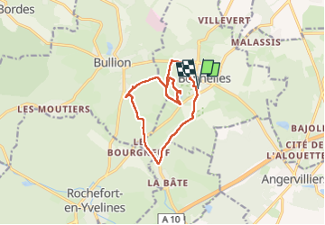

Length
11.1 km

Max alt
166 m

Uphill gradient
140 m
Km-Effort
13 km

Min alt
91 m

Downhill gradient
140 m
Boucle
Yes
Creation date :
2024-02-17 07:33:14.617
Updated on :
2024-02-23 14:52:28.231
2h38
Difficulty : Easy

FREE GPS app for hiking
 SityTrail
IGN / Geographical institutes
SityTrail Plus
The world is yours!
About
Trail Walking of 11.1 km to be discovered at Ile-de-France, Yvelines, Bonnelles. This trail is proposed by Jack-94.
Positioning
Country:
France
Region :
Ile-de-France
Department/Province :
Yvelines
Municipality :
Bonnelles
Location:
Unknown
Start:(Dec)
Start:(UTM)
428316 ; 5385162 (31U) N.
Comments