


SAINTE MAXIME/CHAPELLE SAINT DONAT/POURRIERES/LE REVEST

Michel DUBOIS
User
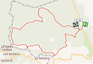

Length
12.5 km

Max alt
376 m

Uphill gradient
474 m
Km-Effort
18.8 km

Min alt
134 m

Downhill gradient
467 m
Boucle
Yes
Creation date :
2024-02-23 15:24:27.677
Updated on :
2024-02-23 15:28:09.649
4h16
Difficulty : Medium

FREE GPS app for hiking
 SityTrail
IGN / Geographical institutes
SityTrail Plus
The world is yours!
About
Trail Walking of 12.5 km to be discovered at Provence-Alpes-Côte d'Azur, Var, Sainte-Maxime. This trail is proposed by Michel DUBOIS.
Description
RANDO modifiée car chemin introuvable au début
Positioning
Country:
France
Region :
Provence-Alpes-Côte d'Azur
Department/Province :
Var
Municipality :
Sainte-Maxime
Location:
Unknown
Start:(Dec)
Start:(UTM)
304649 ; 4806148 (32T) N.
Comments