


T-A53-St-Arnoult-Bonnelles

Jack-94
User
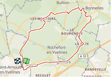

Length
21 km

Max alt
163 m

Uphill gradient
247 m
Km-Effort
25 km

Min alt
86 m

Downhill gradient
247 m
Boucle
Yes
Creation date :
2024-02-24 08:16:08.722
Updated on :
2024-02-24 16:23:05.542
6h12
Difficulty : Medium

FREE GPS app for hiking
 SityTrail
IGN / Geographical institutes
SityTrail Plus
The world is yours!
About
Trail Walking of 21 km to be discovered at Ile-de-France, Yvelines, Saint-Arnoult-en-Yvelines. This trail is proposed by Jack-94.
Positioning
Country:
France
Region :
Ile-de-France
Department/Province :
Yvelines
Municipality :
Saint-Arnoult-en-Yvelines
Location:
Unknown
Start:(Dec)
Start:(UTM)
422467 ; 5380622 (31U) N.
Comments