


pain sorede 2

stef789
User GUIDE
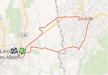

Length
5 km

Max alt
113 m

Uphill gradient
61 m
Km-Effort
5.8 km

Min alt
75 m

Downhill gradient
63 m
Boucle
Yes
Creation date :
2024-02-25 08:55:35.667
Updated on :
2024-02-25 10:01:26.853
1h05
Difficulty : Very easy

FREE GPS app for hiking
 SityTrail
IGN / Geographical institutes
SityTrail Plus
The world is yours!
About
Trail Walking of 5 km to be discovered at Occitania, Pyrénées-Orientales, Laroque-des-Albères. This trail is proposed by stef789.
Photos

Positioning
Country:
France
Region :
Occitania
Department/Province :
Pyrénées-Orientales
Municipality :
Laroque-des-Albères
Location:
Unknown
Start:(Dec)
Start:(UTM)
494849 ; 4707750 (31T) N.
Comments