


St Marcellin AMFB

ramsay
User
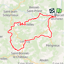

Length
40 km

Max alt
1048 m

Uphill gradient
1017 m
Km-Effort
54 km

Min alt
395 m

Downhill gradient
1017 m
Boucle
Yes
Creation date :
2017-04-20 00:00:00.0
Updated on :
2017-04-20 00:00:00.0
3h26
Difficulty : Medium

FREE GPS app for hiking
 SityTrail
IGN / Geographical institutes
SityTrail Plus
The world is yours!
About
Trail Mountain bike of 40 km to be discovered at Auvergne-Rhône-Alpes, Loire, Saint-Marcellin-en-Forez. This trail is proposed by ramsay.
Description
St Marcellin


Positioning
Country:
France
Region :
Auvergne-Rhône-Alpes
Department/Province :
Loire
Municipality :
Saint-Marcellin-en-Forez
Location:
Unknown
Start:(Dec)
Start:(UTM)
590869 ; 5038931 (31T) N.
Comments